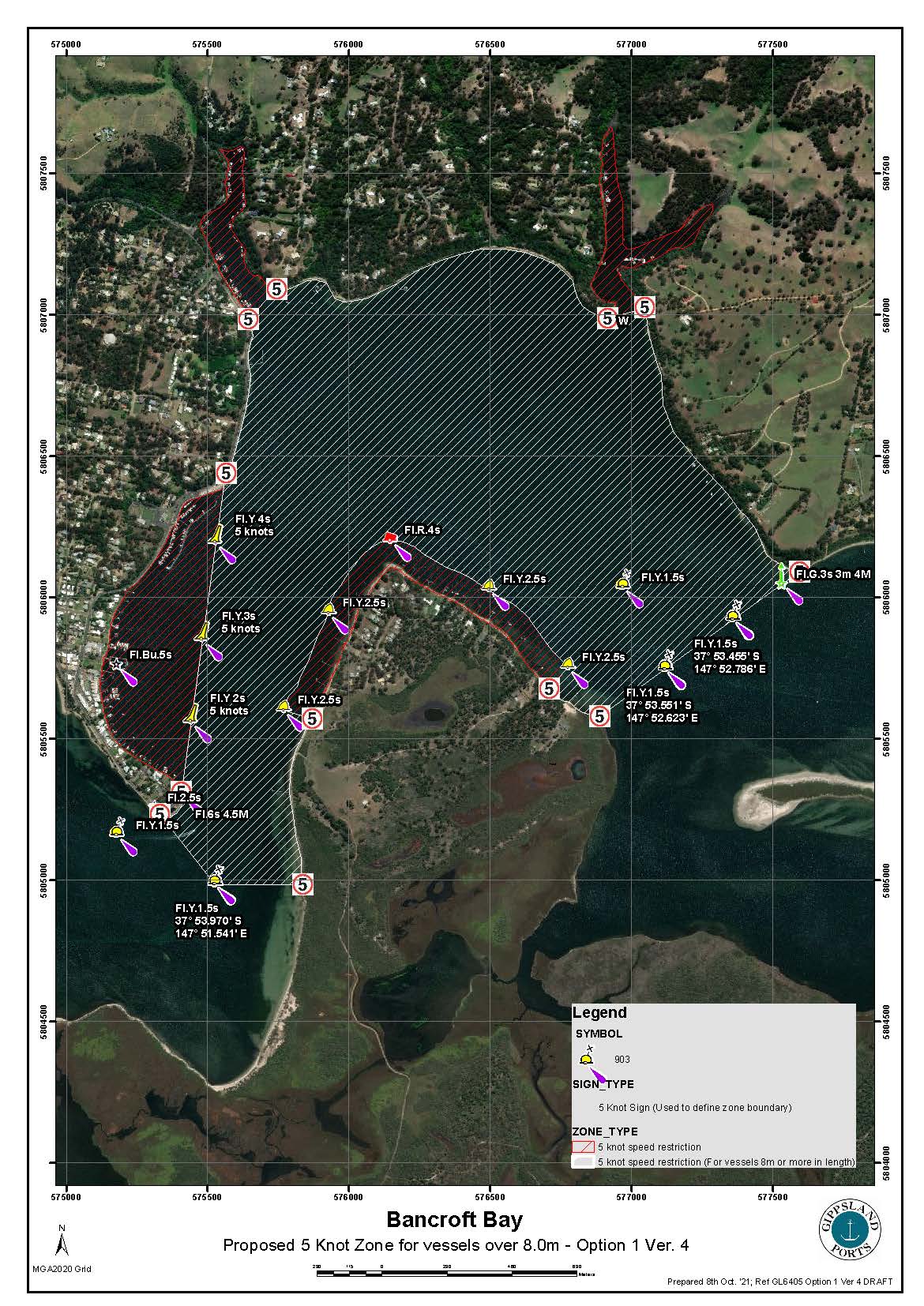
Mariners are advised that following an extensive public consultation and application process carried out by Gippsland Ports the Director Maritime Safety (as Delegate of the Director Transport Safety) has, under section 184 of the Marine Safety Act 2010, made a Vessel Operating and Zoning Rule (VOZR) published in the Victorian Government Gazette on Wednesday 22nd December 2021. The Waterway Rule establishes a NEW 5 knot zone for the waters of Bancroft Bay as described below and shown on the attached Gippsland Ports Map. From the Gazette Notice the new rule establishes a 5 knot zone;
“for powered vessels of eight (8) metres in length or greater for the waters of Bancroft Bay situated between a line from a 5-knot sign on Shaving Point south easterly to a 5-knot sign on the opposite shore and marked midway by a 5 knot buoy, and a line from a 5-knot sign on Bell Point south westerly to a 5-knot sign on the opposite shore and marked by 5-knot buoys”
The new Rule does not affect the existing established 5 knot zones for all vessels as indicated on the attached Map including;
- adjacent to the Metung Township (from Shaving Point to the Metung Yacht Club) and
- Boole Poole Peninsula (surrounding Mosquito Point) and
- the waters of Chinamans Creek and Box’s Creek
The new Rule takes effect immediately following publishing of the Gazette Notice on Wednesday 22nd December and remains in force until 30th June 2023 (the period of the 5-knot zone trial – unless amended). Feedback from waterway users and any incident data will determine the future of the new Zone.
Mariners are advised to ensure they are aware of the new Waterway Rule and to take notice of the recently established buoys and signs when transiting through the Bancroft Bay 5 knot Zones.
Copies of the Gippsland Ports Bancroft Bay Zoning Map and the Government Gazette Notice is available of Gippsland ports website: Notice to Mariners and Warnings – Gippsland Ports


