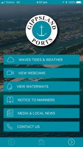
Gippsland Ports has recently developed a Gippsland Ports ‘App’ to offer mobile users direct access to great information from the Gippsland Ports website. With this App, users can check on local conditions before venturing out and can track their travels using the interactive maps for location specific information. Current Notice to Mariners, Local Navigation Warnings, Lakes Entrance Weekly Bar report and the latest news is accessible in the App, whilst users are also able to contact Gippsland Ports via email or telephone.
The App links to live webcam feeds from cameras at Lakes Entrance and Mallacoota, as well as still images from Cape Conran boat ramp, Port Albert and Loch Sport that are refreshed every 1-5 minutes.
As well, the App features real-time weather and tides information for Lakes Entrance and Port Welshpool. The wave rider buoy located 1.5nm SE of the entrance at Lakes Entrance provides users with wave height, direction and frequency and water temperature readings. The Loch Sport and Port Albert sites also provide local real-time weather information.
The ready reference to Gippsland Ports’ Waterways Online (web map) delivers layers of useful information for boaters including the location/GPS points for navigation aids as well as the water depths taken from the most recent hydrographic surveys around Gippsland Ports’ managed lakes and rivers. The tool is interactive and can also plot your current location on the map if the “Location Services” ipad or equivalent option is turned on.
The App is available on the IOS and Android platforms and at only $1.49 provides great value for money.
Executive Manager Corporate Services Steve Martin said “The App is an excellent tool for both commercial and recreational users and covers the waterways managed by Gippsland Ports from Mallacoota to Anderson Inlet, and I invite users to provide constructive feedback to assist with future enhancement suggestions”.
Gippsland Ports App - home screen


